Cycling in the Apuan Alps, Part 1
- Jun 19, 2023
- 5 min read
Updated: Jun 24, 2024

In a previous article I described the Lucca to Massaciuccoli ride as being on some of the quietest roads around Lucca but in fact heading north through the foothills of the Apuan Alps is where you will find some of the most traffic free roads in all of Tuscany. The price to pay of course is that they entail a fair amount of climbing but isn’t that the whole point of cycling?

Some of the routes that I’ll describe here and in future articles are out and back rides or loops but they all have three things in common:
1. They all start by heading due west out of Lucca on Viale G.Puccini because that's the road I live on, but also because after a mere 10 minutes of cycling when you turn onto Via dei Porcaresi you’re home free into the Lucca backcountry north of the river Serchio.
2. They all go past Pieve Santo Stefano and Villa Forci and take the blocked-to-traffic Via di Castagnori down to the crossing over the SP1 main road from Lucca to Camaiore.
3. The routes I describe reflect my personal cycling preference to not spend more time than absolutely necessary exposed to the heavy truck traffic on the SP1 or even the SS12 or SP20 roads that follow the river Serchio down from the Garfagnana to Lucca. But all three of these roads are in fact useful flat/downhill bail-out options if a quick route back to Lucca is necessary because the weather changes, which it frequently does in the mountains, or you just can’t face any more hills on the return trip.

Lucca - Pieve Santo Stefano - Villa Forci - San Martino in Freddana - Loppeglia - Fiano - Lucca
28 miles / 3,000 feet / 2.5 hours
Leaving the Lucca centro storico through Porta Sant’Anna there’s a newish sottopassagio that gets you safely onto Viale G. Puccini and then there’s a shared bike/pedestrian path (ignored by most cyclists) on the right hand side of the road for the first half of the 2.5 miles to the Ponte San Pietro bridge over the river Serchio. Viale Puccini can be a busy road but it’s wide enough for cars to pass you and as soon as you turn right onto Via della Chiesa immediately after the bridge you’re finished with traffic for the rest of the ride.


the sharp left turn turn at the top of Via delle Nubache where Il Vipore restaurant is
Cross straight over Via di Sant’Alessio and continue on Via della Chiesa for about 300 yards and then bear right up and over a tiny bridge over a creek and after another 100 yards bear left onto Via dei Porcaresi. Less than a mile further along with about 3.75 miles on the clock since leaving Lucca bear right at the fork in the road, clearly signposted to Pieve Santo Stefano.
You’re now on Via delle Nubache and it’s a gentle climb of 2 miles with about 500 feet of climbing that takes you up to the sharp left turn onto Via della Pieve Santo Stefano at the restaurant Il Vipore. This was the restaurant where Cesare Casella trained as a chef in his mother’s restaurant before emigrating to America and taking his favorite Canestrino ‘Lucca tomato’ seeds with him.

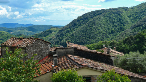
You’re now cycling in the Apuan Alps, or at least the foothills, on roads that are used only by the few locals that live here because for several years there have been no repairs made to the small landslides that fractured both roads leading down to the SP1, as a result of which all through traffic has ceased.
I often walk these roads in the winter when I'm not cycling and Via dei Porcarese in particular is always so quiet that rarely do more than two or three cars pass me during the half-hour it takes me to walk up to Il Vipore.
After Il Vipore there's an abandoned building on the left with the old sign 'Lombardo' still visible. This was the site of an excellent restaurant that a few years ago moved down the hill to Santa Maria a Colle just west of Lucca. The restaurant is still excellent but the outside space is not quite the same.


Shortly after passing il Vipore you come to a T-junction with the small hamlet of Pieve Santo Stefano off to the right. Instead you go left, following the signs to Forci and Castagnori (photo top left below). The almost two miles from Il Vipore to Villa Forci includes another 400 feet of climbing but it’s a gorgeous road with great views and almost no traffic because Villa Forci owns about 900 acres of land either side of the road so there are very few houses around here.
It’s a tranquil area dotted with olive groves and wineries, including Villa Sardini and Villa Santo Stefano and looming up ahead you'll see the big mountains of the Apuan Alps but they're not on the itinerary for this particular ride.

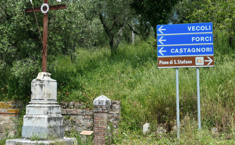


Passing Villa Forci with about 8 miles on the clock you take the blocked off road on the right signposted to Castagnori (photo top right above) where the descent starts.
The road is in fairly good condition given the reduced maintenance for several years with the only problem being a small section that was washed away a few years ago (photo bottom left above). There's a well worn path to the side which is only a few yards long so it's very easy to get around the problem and after that the rest of the road is mostly fine.

The two mile descent to San Martino in Freddana is quite steep towards the bottom and you’ll have this very short section of 10-13% gradients to look forward to on the return but the total elevation change of the climb is only about 700 feet.


At the main road you go left for only about 50 yards and then take the first right turn signposted to Loppeglia and Fiano (photo right).
From this turning it’s about 4.5 miles to the church in Fiano with no more than 1,000 feet of climbing; until the last mile it’s mostly 3-4% gradients so nothing too challenging and even the final leg through the village of Loppeglia is not terribly steep.
Fiano is the final destination on this ride and marks the turnaround point for this particular route. Going all the way to Pescaglia involves another descent and another climb, so I'll cover that another time.


A few hundred yards past the church in Fiano (above photo right) is where the descent towards Pescaglia begins so anywhere before that is a good place to turn around.
The Giro d'Italia skirted Lucca this year on Stage 10 coming through Monte San Quirico and San Martino in Freddana on the way to the finish in Viareggio . It seemed like it rained just about every day of the tour for them, including the whole day on Stage 10.


