Bagni di Lucca and back, the hard way
- Sep 7, 2023
- 5 min read
Updated: Jun 24, 2024
Cycling in the Apuan Alps, Part 2 60 miles / 6,700 feet / 5.25 hours

This is one of my favorite long rides out of Lucca because although there are many others that go much deeper into the Apuan Alps or Garfagnana they involve more time on major roads and in any case 5 hours or so is about my maximum these days for a bike ride to be enjoyable.
There are 4 climbs on this route and they get progressively harder as follows:
Via dei Porcaresi to Villa Forci: 1,000 feet at an average of 4.3%
San Martino in Freddana to Fiano church: 1,200 feet at an average of 5.0%
Passo del Trebbio from Bagni di Lucca: 1,900 feet at an average of 6.3%
Altopiano delle Pizzorne from Villa Basilica: 2,200 feet at an average of 8.1%

The initial 14 miles that include the first two climbs cover exactly the same ground as the out and back Loppeglia / Fiano ride but instead of turning around just past the church in Fiano you keep going in the direction of Pescaglia.
A short 1.5 mile descent brings you to an important crossroads for Lucca cyclists. Straight on is Pescaglia, San Rocco etc and for hikers the way also to Monte Matanna. Left is another great cycling loop taking in Gombitelli and Massarosa on the return leg to Lucca.


The route described here however requires a right turn where 50 yards further on, opposite the restaurant (photo above right), is a convenient water fountain to replenish your water bottles, following which there is a fantastic 5 mile shallow descent on a mostly straight low-traffic road. With very little peddling it’s an easy 25 mph ride to Diecimo where you turn left onto the main road from Lucca to the Garfagnana which follows the river Serchio upstream.

(Note that the map above has the famous Ponte della Maddalena in the wrong place on the wrong river near San Martino in Freddana. It's real location is on the Serchio just north of Borgo a Mozzano)
To reach Bagni di Lucca and the quiet back-country roads you first have to put up with 3 miles on this busy section from Diecimo to Borgo a Mozzano, much of it however with a reasonable shoulder area providing a margin of safety. It’s the least enjoyable part of the ride but is much better on weekends without all the trucks.

At Borgo a Mozzano you take the right turn across the bridge over the Serchio and then immediately left on highway 12 (the Lucca to Abetone road) for the flat 2.5 miles to Bagni di Lucca. You’ll pass the historic Ponte della Maddalena, a medieval marvel dating back to the 14th century, and once in the center of Bagni di Lucca a left turn across a very small bridge brings you to a convenient and relaxing coffee and refueling stop at Bar Italia.

Continuing east on highway 12 from the center of Bagni di Lucca, after about 1.5 miles you’ll take the small road uphill on the right signposted to Benabbio. There’s also a coffee shop and water fountain here on the left hand side.

This is the start of the 3rd climb, called the Passo del Trebbio. It’s a very pleasant section of just under 6 miles with no really challenging gradients (most of it being between 4% and 7%) and you’ll have the road to yourself; I rarely see cars or even other cyclists.
Just under half way into the climb is the small village of Benabbio with a water fountain and a bar in the central piazza, after which the ascent continues up to about 2,400 feet. The high point is a little distance after the Villa Basilica sign but you won’t know that you’ve actually peaked until the road starts going downhill because there’s no sign saying Passo del Trebbio.


The inscription above the water fountain (above left) commemorates the milestone of 1,000 years of the history of this village from 983-1983. Amazing for a tiny out-of-the-way place like Benabbio.

The descent to Villa Basilica starts quite gently as you pass through several villages and then becomes steep and quick with the potential for some very large trucks on the lower section that can take up most of the narrow road.

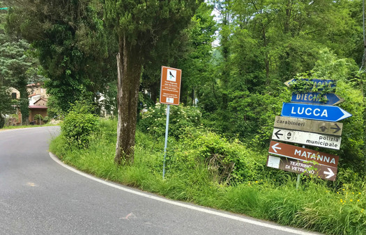
After exactly 6.4 miles the main road continues with a slight curve to the left whereas the road to the Altopiano delle Pizzorne is straight on (photo below). There’s no sign unfortunately and I completely missed it the first time I tried out this route and even the second time I had to ask at the coffee shop which sits in an open area between the two roads. In front of the coffee shop at the side of the road there is another water fountain.

Having descended to an elevation of about 800 feet the 4th and final climb starts here, topping out at 3,000 feet. This is the alternative route up le Pizzorne and preferred by many Lucca cyclists because it’s less steep than the main route up from Matraia.
I still prefer the Matraia route myself because the direct route to Villa Basilica from Lucca involves very busy roads. And this brings up another point, if you can’t face yet another climb at this stage of the ride there is a bail-out option which is to continue left on the main road down through Collodi and take the main road (#435) that goes straight back to Lucca and is mostly flat. I’ve taken this option myself in the past when not quite fit enough to manage the final climb on a hot day.

The climb up to the village of Pizzorne is about 5 miles with 2,200 feet of elevation gain and there are some steep sections. For me at least it’s always a tough climb because of fatigue and the summer heat.
The first mile is very gentle, at the end of which you take a left turn, which this time is well signposted, to the Altopiano delle Pizzorne and then the harder gradients begin. The next 3 miles are mostly in the 9%-10% range before it eases off in the final mile.

The small spread out village at the summit can be a bit confusing so it’s best to take Via delle Lame and continue straight on Via del Romitorio and then when you reach the small downtown area with a few restaurants and a large park go left on Via Pietra Pertusa at then end of which you’ll see a sign on the right to Lucca. Then it’s all downhill to Villa Reale and a flat 6 miles back to town.


